
Tropical Storm Ivo caused heavy rain, lightning, flooding, and rescue operations in Mazatlán yesterday. Streets filled with water, and thunderstorms lit up the night sky.
Storm’s Position and Strength
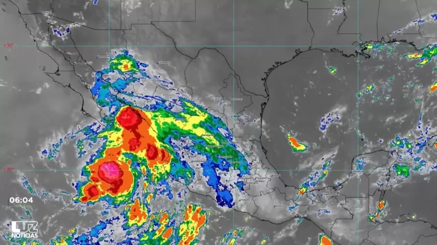
As of 6:00 a.m., the National Meteorological Service reported Ivo about 275 km south of Cabo San Lucas, Baja California Sur. It carries sustained winds of 95 km/h and gusts of 110 km/h, moving west-northwest at 33 km/h. The storm is expected to strengthen to a Category 1 hurricane tonight before weakening on Sunday.
Why Sinaloa Was Affected
Meteorologist Juan Pablo Cerón from Civil Protection explained that Ivo’s circulation pulled moisture into Sinaloa. This moisture interacted with low-pressure systems over the Sierra Madre Occidental and the Mexican monsoon, triggering intense rain.

Rainfall by Region
Today, heavy rain (50–75 mm) may fall in mountains near Chihuahua and Durango. Municipalities like El Fuerte, Choix, Culiacán, Cosalá, San Ignacio, and Concordia may see 25–50 mm. Mazatlán, Rosario, and Elota can expect lighter showers.

Yesterday’s Rain Totals
Official rainfall totals for Mazatlán will be released by the SMN at 11 a.m. Private weather stations showed big differences, from 60 mm at the Navy’s port authority station to over 100 mm in other areas.
Forecast for the Weekend
Coastal rain intensity in the south should decrease today. However, mountain areas may still receive heavy showers. The chance of rain remains through the weekend as Ivo’s circulation continues to push moisture into Sinaloa.